Atlas of Monferrato
Cartosio: sights, history and trails
Alessandria
- Elevation
- 230 m above sea level
- Area
- 16.34 km²
- Demonym
- cartosians
- Patron saint
- Saint Andrew
A closer look
Discovering Cartosio
Cartosio (Cartos in Piedmont) is an Italian municipality of 701 inhabitants[1] from the province of Alessandria in the Piemonte.
Landscape and area
Region · Geology · Natural HistoryExplore this chapter
Region
The territory of the municipality of Cartosio is mainly hilly, with the Erro stream that flows in the center of its valley. The town is located on a river shelf formed after erosion by the creek of sedimentary rocks of the valley floor. To the south of the village lies the hill of Pallareto, which means “child neckline”, because of its shape, that covers the valley, at whose feet opens a flat agricultural area. In the east, the wooded reliefs that have as a climax rise Ponzone, which is a mountain, as it is at an altitude higher than 600 m above sea level. To the north, the narrow incised valley of the Erro opens into a wider valley, dominated by the Bancarelle hill, which marks the border with the municipality of Melazzo. To the west, on the border with the municipality of Montechiaro d'Acqui, an imposing hill rises up, called "I Carozzi", which means "hill/height of stones/stony", on the top of which the antennas and repeaters for telecommunications have been installed. The inhabited center is bordered to the east by the 10 m deep gorge of the Retano della Villa, which divides near the football field and takes the name of Rio Niscarone, which drains the plain south of the village and the surrounding hills.
Geology
Cartosio is part of the last slopes of the Ligurian Apennines, which then degrades towards the plain. The rocks of the territory are three main natures: to the south the rocky substratum is constituted by ofiolites of the Voltri group, formed in the late Jurassic, whose properties allow the water to infiltrate and, after about 8000 years, to re-emerge at the thermal springs of the neighbor Acqui Termebelow the village, in the centre, there are sedimentary rocks with cemented pebbles, belonging to Molare formation, probably formed in an ancient river delta during the Oligocene, about 33 million years ago, covered by clays and river sands of the Middle Pleistocene, finally belonging to the northern reliefs can be seen deep calcareous and sandstone rocks, locally called tu Rocchetta Palafea, also called Rigoroso, formed after that of Molare about 29 million years ago in deeper waters. The region probably emerged following the Apennine orogeny in the Neogene and was later sculpted by atmospheric and fluvial agents to create the current valley, characterized by various river terraces witnessing various degrees of erosion by the stream and deep canyons of the lateral streams.
Natural History
The municipality is located in the ecoregion of the forests of sclerofille and semi-deciduous Italians, within the bioma of the forests, woods and Mediterranean scrub in the palearctic biogeographic realm. When the first human beings settled in the area, the territory was part of the steppe of the mammoths, an arid and cold biome, which extended to Siberia. After the deglaciation, about 10,000 years ago, the steppe disappeared and left its place in the current forests. The flora is made up of oaks, chestnuts, even if planted by man, cherries, plums, poplars, willows, hazelnuts and nuts. Weeds are the robines, called fodders, which in some places promote only the growth of the roars, suffocating other plants. In spring, in the meadows, it is possible to admire rare species of wild orchids, which has been tried to safeguard through initiatives sponsored by the municipal administration. It is not rare in the woods to find specimens of wild pine, sometimes planted at times spontaneous. Late summer and early autumn, if the weather conditions are right, it is abundant mycelic growth. Land wildlife until a few years ago consisted of small mammals and only two species of large ungulates, wild boar and roe. In the last decade, it has witnessed the return of the Italian wolf, even if its numbers are still too low to control the population of herbivores. Bats were also observed. The area in spring and autumn is witness to the passage of cranes and geese into migration. The species of seasonal birds include real Germans, sparrows, pettyroxes, histories, buzzards, falcons, green peaks, cinerini herons and larger white herons, pigeons, doves, owls and upupa, while in summer there are swallows. Historically, the presence of lontra, eel and river shrimp had been reported in the Erro stream. The situation has worsened when the presence of the silurian fish, released illegally, has been reported. Overall biodiversity is still very low, but hopefully it will increase in the future, becoming also an attraction for eco-tourism.
Climate
| Spigno Monferrato | Months | Seasons | Year | ||||||||||||||
|---|---|---|---|---|---|---|---|---|---|---|---|---|---|---|---|---|---|
| Gen. | Feb | Mar | Apr | May | ♪ | Jul | Ago | Set | Oct. | No. | Dec. | Inv | Pride | East | Aut | ||
| T. max. average (°C) | 5,6 | 9,8 | 14,4 | 19,3 | 24,0 | 27,8 | 30,6 | 29,2 | 24,9 | 18,1 | 11,0 | 7,0 | 7,5 | 19,2 | 29,2 | 18,0 | 18,5 |
| T. min. average (°C) | −2,6 | −0,8 | 3,1 | 7,4 | 11,1 | 14,6 | 16,3 | 15,6 | 12,6 | 7,7 | 3,3 | −0,4 | −1,3 | 7,2 | 15,5 | 7,9 | 7,3 |
- Climate classification: zone E, 2504 GG[4]
Origins of the name
The name of Cartosio appears in documents dating back to the 11th century under the name of Cartosium . The name could derive from the Ligurian root preindoeuropea kart that would indicate...Explore this chapter
The name of Cartosio appears in documents dating back to the 11th century under the name of Cartoon. The toponym could derive from the pre-Indo-European Ligurian root karting which would indicate a clearing or field, while -osium was a common suffix in medieval Latin to indicate territories. It is probable that the name originally indicated the territory of the valley, and then became in the name of the village. So he would say, “place of the fields.”
History of Cartosio
Antiquities · Middle Ages · Modern ageExplore this chapter
Antiquities
The region of Cartosio has been inhabited since time immemorial. Before the Roman conquest the area was inhabited by a tribe of Liguri, the Stazielli, who had as center the oppidum of Caristum. Although the name of the ancient city has a certain resemblance to that of the present village, modern historians believe it was modern Acqui Terme. In 173 BC. the Romans defeated the Stazielli and began to romanize the region with the foundation of Aquae Statiellae, Acqui, attracted by the healing thermal waters. To serve the city, an aqueduct was built at the time of Augustus, the mostly underground remains of which have been identified. The source of the aqueduct was located in today's municipal territory of Cartosio, as demonstrated by the presence, under the Tempuccio locality, of a hole in the rock of the river bank, although there was probably another outlet further upstream, probably in Lagoscuro, which was never found. The valley, in Roman times, was probably cultivated and developed, given that in the past there were occasional discoveries of archaeological finds, which were never investigated more thoroughly.
Middle Ages
Following the fall of the Western Roman Empire in 476 AD, with the decline of large urban centers, the population fled into the countryside, perched on the hills to protect themselves from raids. Following the creation of the Lombard kingdom, the border between it and the possessions of the Eastern Roman Empire ended up passing through the municipality of Cartosio, as evidenced by the discovery of a wall dating back to that period in the fraction of Rivere. The first town of the valley was called Borgo and did not correspond to the modern one; but it was just less than 1 km north-east, where there is still the church of San Pietro, traditionally considered the first in the area. In the upper Middle Ages Cartosio was part of the Brand Aleramica, later being owned by the marquises of Ponzone. Around the 12th century a county was created and the municipality passed to the Asti family of Asinari, who owned it for centuries until around 1815. A popular legend states that at the time the tower was already present in its current position and was partly demolished by the people of Asti, who rebuilt it in its current form and founded an entire inhabited center around it, intended for the military, with suitable entertainment, while the majority of the civilian population continued to reside in Borgo, which however within a few centuries was abandoned due to the landslides to which it was subject. Also in the 12th century, following the fate of its mother city, Acqui Terme, the county of Cartosio became part of the Marchesato del Monferrato. In that period the town was of vital importance, as it was crossed by an ancient road that led to the sea and to the salt pans and clay quarries of Albisola, whose products were in demand in the hinterland.
Modern age
After the Spanish Succession War and in accordance with the Treaty of Utrecht, 1708 Cartosio He became part of the lands of Savoy, whose lands lasted first and then king continued to invest the Asinari of the county. The territory saw huge destruction and passage of countless enemy armies and friends, who did not benefit the already precarious life of the mass of peasants. During the Napoleonic wars, for example, before the transit of the Austro-Saabada army to Savona took place, and then the short passage of the French one, directed at Acqui, where Napoleon was, who remained there a few days before heading towards Marengo. Following the annexation of Piemonte to the French Empire, Cartosio he joined the Montenotte department, except to be recovered from the Savoy after Napoleon's defeat of 1814-15.
Contemporary age
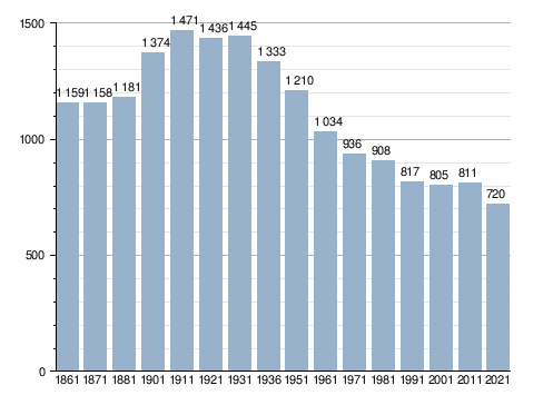
After the Congress of Vienna, the Asinari extinction and the abolition of fiefs, the former contea was reorganized in a common primitive, keeping its old borders, explaining the presence of an exclave not connected to the rest of the municipal territory, near an ancient cipollino marble quarry. In the 1836 Cartosio it was hit hard by a cholera epidemic that causes the population to fall from 500 alone 100 individuals and that prompted the authorities to transfer the cemetery from the surrounding area of the parish church, which was extended to the present location. In the following years the population grew again and in the early 20th century almost 1500 inhabitants between the country and the various hamlets and localities. In the years '70 in the 19th century it was proposed to pass the railway between Acqui and San Giuseppe di Cairo for the town, but the population opposed and chose the current route. The country’s participation in the First World War is witnessed by the monument in the square, under the tower, which commemorates the falls of I, World War II and the war of Ethiopia. In the years '20 the castle was sold to private and demolished except a few leftovers, leaving the tower as the last testimony of the medieval military past of the center, but it also fell into ruin. In this period the tradition of organizing a festival spreads 1º May of each year, which initially was a polentata. In the 1936 copper pot was given away to contribute to the war efforts in Ethiopia and polenta was replaced by pancakes. During World War II in the area there were partisan groups, but fortunately there were no reprisals from Nazis and fascist collaborators. The post-war period was marked by a constant decline in the population and today it is estimated that 575 people, while the abandonment of the countryside has allowed wildlife to claim what was once its own, with the return of wolves, but also with the unbearable local extinction of the eel and otter, most likely caused by the serious pollution of the Bormida, that the eels traveled to reach the Erro, and from the construction of more and more bridles and cheeks on the latter who trap sediments, alter the normal river course and I can worsen floods, as well as prevent the fish from going back. In addition, about in 2014, an unknown has illegally freed the sour fishes in the aforementioned Lagoscuro, which have spread upstream and downstream and discarded the autochthonous fish population, which is now limited to some rapids. In the years80 the restoration of the tower, with the restoration of the interior and the realization of a spiral staircase for access, not the original one, but one realized in the nineteenth century, and a parapet on the top, even if restricted, made by two premises, Domenico Romano and Vittorio Milano. During the term of Gianni Pettinati, in 2004, the communal swimming pool was inaugurated, a remarkable attraction during the summer, which in 2023 was dedicated to the late mayor overlord. In the 2014 the tower has been subject to additional restorations and modernizations to allow visit to all its parts with the remaking of the flooring of the top and laying of a railing on board that replaced the old much closer, while a football field for the boys was created in replacement to the previous polyspora complex entitled to Giovanni Pettinati, native cyclist of Cartosio, franate a few months after his restructuring of 2011 and now in the process of remediation.
Symbols
The coat of arms and gonfalone were granted by decree of the President of the Republic of 17 May 1983.[5]
The gonfalone is a truncated drape of green and yellow. On 29 September 2024 for the first time, next to the Italian flag, the banner of the municipality was placed on the top of the tower, based on the gonfalone, followed on 11 October by the European flag, arranged in accordance with the ceremonial state.
What to see in Cartosio
Religious architecture · Church of St. Andrew Apostle · Other churchesExplore this chapter
Religious architecture
Church of St. Andrew Apostle
The parish church of Sant'Andrea apostle was built before 1600, even if the exact date is ignored. It was modified several times over the centuries: according to Goffredo Casalis the church was rebuilt in 1619, Father Gabriele Roffredo built the main altar in 1701, Don Carlo Giuseppe Scazzola expanded and restored the building in the second half of the nineteenth century by equipping it with a protiro and a baroque door.
The church is divided into three aisles each time separated by two rows of columns, it is about 14 meters long including the presbytery and is about 11 meters wide. It has a bell tower about 35 meters high with 6 bells. According to the Report of the state of Sant'Andrea Parish in the place of Cartosio, written by Don Carlo Giuseppe Scazzola around the 1830s, there were five altars: in the presbytery the main altar, in the right nave the altar of Sant'Anna and that of the Holy Rosary, in the left nave that of San Concesso (from 1705) and that of San Sebastiano. Currently, in addition to the main altar, only two altars exist.
The interior of the church was largely frescoed by Lorenzo Lajolo (1877-1947) in the early 20th century. On the sides of the main altar there are two of its frescoes representing theAnnouncement and theOration in the garden of olive trees made with the technique of dry fresh. They illuminate the environment ten stained glass windows produced by Gibo.
Other churches
- Church of San Rocco and San Sebastiano: oratory built in 1694 the seat of a brotherhood and transformed into asylum in 1954.
- Church of N.S.G.C. Ascension of the village.
- Church of the Nativity of Virgin Mary: in the Region of Pallareto.
- Church of San Bernardo and San Defendente: in the hamlet of Saquana.
- Church of San Rocco: in the Region of Castellarolo.
- Church of San Martino: built in 1636 near Borgata della Colombara. It was rebuilt after a flood.
- Church of Sant'Antonio Abate: built in 1631 in the Borgata della Caliogna.
- Church of the Blessed Virgin of Sorrow: built in 1714 in the region Oltre Erro.
- Church of San Pietro Apostolo: in the Region of Piano, on the road to the hamlet Garini.
- Church of San Giovanni Battista: built around 1923 in the hamlet of Rivere.
Military architecture
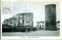
In the 1920s, the ruins of a feudal castle were still visible between the 13th and 14th centuries, built in turn on pre-existing ruins that are not datable. Today, two private houses rise.
The village is characterized by the tower of Cartosio, a medieval tower that stands out in the center of the main square which was built between the 12th and 13th century by anonymous builders, but probably coming from Casale Monferrato.
The tower was built with the local sandstone cemented with cones. It is 22.4 meters high and has a rectangular plant that shrinks until the beginning of the vertical position at 4.3 meters from the ground: the sides at the base measure 10,0 and 8,2 meters and shorten to 9,6 and 7,8 meters. Originally the tower reached 25 meters high because it had a merlate parapet, destroyed on 2 December 1296 by the Astigiane militias.
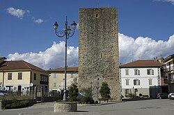
It is formed by seven floors of a single compartment: the first (interrate for four meters), the second, the fourth and seventh are at times and the other three floors were covered by a wooden table, removable, now demolished. The floors were not connected by a staircase around the wall, but with quadrilateral traps placed at the northwest and southeast corners. The first floor was used as a cistern and fed by water still alive today, the second was a prison, the fourth was a warehouse of food supplies, the fifth was intended for kitchen and canteen, the sixth was a dorm while the seventh served for sighting and from here could reach a terrace for the watch.
Particularity of this tower, unique in Monferrato, is the presence of an opening called "pustella" in the outer wall west at 11.5 meters from the ground. At this opening it was accessed through a drawbridge that rested on a wall of the adjacent castle today no longer existing.
Monuments
Monument to air disaster
On the road that leads from the village to the Pallareto Region there is a monument dedicated to the falls of an air accident occurred on site in the morning of 7 December 1940. On that day a Savoia-Marchetti S.M.79 took the lead due to an early engine or bad weather, causing General Pietro Pintor's death, head of the Italian Commission of Armistice with France (CIAF), and its six subordinates: General of aerial team Aldo Pellegrini, Col. Pil. Attilio Corti, Magg. Cesare Quinto, Cap. Pil. Giuseppe Cadel, M.llo 2o cl. Ettore Alberi, Serg. Magg. Paolo Cinti. The monument consists of a semicircular base on which is placed a pile of white stones that supports a marble stone and a broken propeller of the plane.[8]
Monument to the Falls
Near the tower there is a monument dedicated to the fallen of the first and second world war consisting of two marble slabs on which the various names are written.
It was inaugurated on 19 September 1920 and consisted only of the plate dedicated to the dead in the Great War attached to the south side of the tower at a height of about two meters from the ground. In the following years a fountain was dug and a garden was built below it.
During the restoration of the tower, which took place in the early 1990s, the plates were moved to the present place and placed on a new base with a fountain in the center.
Society and local culture
Demographic evolution · Holidays and eventsExplore this chapter
Demographic evolution
Holidays and events
At present, 4 festivals are held in Cartosio, organized by the municipal administration and Proloco: fruity spring, on the third Sunday of March, focused on fruit plants and grafts; the Fries’ Day, on the fourth Sunday of May, the oldest in the country, with distribution of pancakes all day; the chestnut festival, on the second Sunday of October and a fruitful autumn, on the second Sunday of November. During the morning they usually walk in the surrounding countryside, while in the afternoon there are conferences in the square together with a market. In summer, the Mangialonga is held, a night walk with tasting of local products, followed by a refreshment and a mini party in the football field. Until 2019 it was customary to organize, on the 3rd Saturday of August, Asado, a great evening made with meat with tables arranged in the square, which culminated with the arrival and distribution of a giant cake on a wagon and, in the last editions, in a disco; after 2020 it was no longer organized, but it is thought to reintroduce it as it was a very rooted tradition.
Ethnic minorities
At 31 December 2010 in Cartosio were resident 83 foreign citizens, representing 10.23% of the population. The largest national community is the Moroccan community with 36 people, followed by the Romanian community with 15.[12]
Administration
Other administrative informationExplore this chapter
Below is a table relating to the administrations that have succeeded one another in this municipality.
| Period | First citizen | Match | Load | Notes | |
|---|---|---|---|---|---|
| June 28, 1985 | May 21, 1990 | Wishing Morena | civic list | Mayor | [13] |
| May 21, 1990 | April 24, 1995 | Francesco Gaino | civic list | Mayor | [13] |
| April 24, 1995 | June 14, 1999 | Wishing Morena | center | Mayor | [13] |
| June 14, 1999 | June 14, 2004 | Gianlorenzo Pettinati | civic list | Mayor | [13] |
| June 14, 2004 | June 8, 2009 | Gianlorenzo Pettinati | civic list | Mayor | [13] |
| June 8, 2009 | May 26, 2014 | Francesco Mongella | civic list | Mayor | [13] |
| May 26, 2014 | May 26, 2019 | Mario Morena | Civic list Doing community | Mayor | [13] |
| May 26, 2019 | June 9, 2024 | Mario Morena | Civic list Doing community | Mayor | [13] |
| June 9, 2024 | in office | Mario Morena | Civic list Doing community | Mayor | [13] |
Other administrative information
The commune was part of the Montana Suol d'Aleramo Community.
Image gallery
Explore this chapter
-
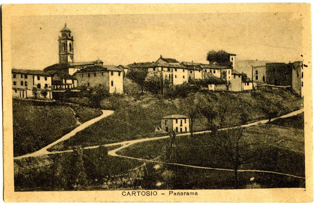
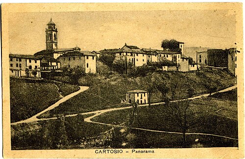 The panorama of Cartosio in the years '30 - '40
-
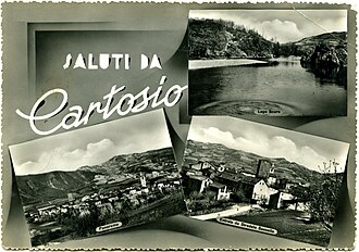 Cartosio - Postcard '60s
-
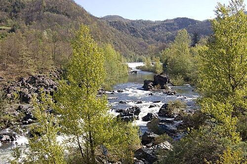 The Erro Tower
Notes
Explore this chapter
- ^ to b Monthly demographic balance for the year 2026 (provisional data), up demo.istat.it, ISTAT.
- ^ Seismic classification (XLS), up risks.protezionecivile.gov.it.
- ^ Table of degrees/day of Italian Municipalities grouped by Region and Province (PDF), in Law 26 August 1993, n. 412, annex A, National Agency for New Technologies, Energy and Sustainable Economic Development, 1 March 2011, p. 151. URL consulted on 25 April 2012 (archived fromoriginal url on 1 January 2017).
- ^ Climate table Piemonte, up conf building.it. Retrieved 16 July 2009 (archived fromoriginal url on 13 March 2009).
- ^ Cartosio, up Central State Archive.
- ^ Cartosio, up araldicacivica.it.
- ^ Piedmontese civic coat of arms, vol. I, Regional Council of Piemonte, 2016, p. 113, ISBN 978-88-96074-98-5.« Red, natural bull, born from the field of green wheat, to the canton frank grape bunch, in the other the tower to the natural. Exterior ornaments from the Municipality.»
- ^ Association Arma Aeronautica celebrated 25 years, in The anchor. Retrieved 30 July 2011 (archived fromoriginal url on 1 March 2015).
- ^ Data taken from:
- Resident population of the municipalities. Censuses from 1861 to 1991 (PDF), up ebiblio.istat.it, ISTAT.
- Resident population - Time series, up exploredati.istat.it.
Please note: 2021 data refers to permanent census data as of December 31 of that year.
- ^ Louis Marie Prudhomme, Dictionnaire universel, géographique, statistique, historique et politique de la France, Baudouin, 1804, p. 552.
- ^ Goffredo Casalis Geographical-historical-commercial dictionary of the states of S. M. the King of Sardinia, volume III, Turin, 1836, p. 650.
- ^ Demographic statistics ISTAT, up demo.istat.it. Retrieved 30 December 2011 (filed on 22 June 2013).
- ^ to b c d And f g h the http://amministratori.interno.it/
Bibliography
Explore this chapter
- Constantine Umberto Padovano, Cartosio. History of a country in the Upper Monferrato, 1994.
- Francesco Pernice (edited by), Luigi Moro, The medieval tower of Cartosio. Restoration, Daniela Piazza Editore, 1993, ISBN 88-7889-018-9.
- AA.VV., Land, customs and peasant civilization in Cartosio, Graphic Impressions, 2010, ISBN 978-88-6195-049-8.
Where to stay · Cartosio
Find stays on Booking.comThe area, step by step
Trails and routes in Cartosio

Asti, Alessandria and surroundings
The Wine and Flavor Route · Aromatici · Montechiaro–Roboaro

Asti, Alessandria and surroundings
Acqui Terme e la Valle dell’Erro
Asti, Alessandria and surroundings
Enduro dei 3 Fiumi in Mtb
