A closer look
Villa del Foro: at a glance
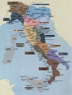
(Pliny the Elder thus recalls one of the main centers of the IX Regio Augustea)
Villa del Foro is a hamlet of the municipality of Alessandria in the Piemonte.
Physical geography
The hamlet of Villa del Foro is located in the western part of the municipality of Alessandria, on the right bank of the Tanaro River near the confluence between Tanaro and...Explore this chapter
The hamlet of Villa del Foro is located in the western part of Alessandria, on the right bank of the river Tanaro near the confluence between Tanaro and the torrent Belbo, and borders the hamlets of Casalbagliano, Cantalupo, the municipalities of Castellazzo Bormida And Oviglio, the northern border of the hamlet is represented by the river Tanaro.
History
Roman epoca · Retrovaments of the Roman Age · 12th centuryExplore this chapter
Villa del Foro has been known since ancient times, it was an important center in prehistoric and protohistoric times as the numerous finds show: nearby there were some tombs dating back to the culture of urn fields, to the proto-celtical cultures of the Ligurians and precisely Celtic during the Iron Age. It became a Roman settlement with the name of Forum Fulvii to enter into decadence in medieval times.
Roman epoca
According to today's most accredited hypothesis Forum Fulvii was established at the end of the 2nd century BC. by the console M. Fulvio Flacco, committed between 125 and 123 BC. in a military campaign Monferrato against the populations of Salluvi And Votes in support of the city Massalia (today Marseille). The conquest of the region was accompanied by an intense work of administrative reorganization of the same through the opening of a large consular road, today conventionally indicated as via Fulvia from the name of its promoter, and from the foundation of several centers along its path. Many of them also, including the same Forum Fulvii, were established in localities already affected in prehistoric and protohistoric times by the presence of even temporary settlements and various forms of more or less stable frequentation: the Roman intervention was therefore configured not so much as a real deduction of new colonies, but rather as a re-foundation of pre-existing communities which in this way were framed in the Roman system. This solution was accompanied by the practice of viritan assignments, that is, the assignment of lands to be cultivated to individual settlers ("viritim" precisely: these were largely veterans who had arrived on leave and possibly originating from the areas where they were resettled) who continued to formally depend on Rome from a legal and administrative point of view.
The absence of new colonies required the presence of hole And Conciliation, that is, places that acted as a point of reference for a form of scattered population of the region in which to trade, meet, celebrate common holidays and rites and obtain justice in the event of legal disputes and trials. In these centers, contact between the native population and the new settlers was also encouraged and stimulated, facilitating the process of progressive Romanization of the territory and acceptance of Roman culture among the local people.
Born then as forums At first perhaps the dependencies of Tortona, Forum Fulvii was assigned to the Tribus Pollia and in the course of the 1st century BC. its full integration into the Roman administrative system through a process by degrees that will see the acquisition of Latin citizenship in 89 BC. Following the conclusion of the social war, obtaining Roman citizenship in 49 BC. and finally, with the abolition of the provincial regime for Cisalpina in 42 BC, full legal equivalent to the rest of Italy. Entered within the Regio IX Liguria following the reform of Augustus, perhaps immediately after 42 BC. or later in the august era became municipium equipped with its own autonomy and with a territory of relevance whose limits are difficult to define, bordering east with Dertona, south with Acqui Terme, to the west with Asti and to the north with Casale Monferrato.
During the 1st and 2nd century AD. the centre benefits from the general climate of prosperity and well-being that crosses the Empire, basing its economy on the exploitation of agricultural resources, on handicraft activities connected with the processing of clay and iron and commerce, facilitated by the passage of the via Fulvia and probably also from the close connection with the Tanaro. The findings of domus of value as well as of import materials seem to confirm the richness of a city that is not by chance therefore it is counted by Pliny the Elder among the main ones of the region.
From the 3rd century A.D., and in particular from the middle of the same in conjunction with a general crisis situation of the Empire, Forum Fulvii saw the start of a process of decline from which it seems not to have been able to rise again in the following centuries, with a progressive depopulation of the territory and a loss of importance of the consular way, to which other paths were preferred over time that therefore caused a decentralization of economic and commercial interests regarding the area of the municipium.
Retrovaments of the Roman Age
The Forum was located along the road today conventionally referred as via Fulvia, which gives Dertona He was going to Augusta Taurinorum through the territory of Asti, and then probably continue in the direction of Segusium and from here in the Gallic territory. A stretch of the road, between 9 and 12 m approximately, was found in San Damiano, west of the current town: it belongs to the type of roads glare, i.e. equipped with a cobblestone floor, and appears to have been built in two distinct phases. The first system dates back to the end of the 2nd century BC, coinciding with the establishment of the Roman centre, with an accurate technique which involved the creation of two preparatory layers on which the road surface rests; this route was used continuously until the beginning of the 1st century AD, with a progressive narrowing of the roadway due to alluvial deposits on its edges and the use of the same as a site for some cremation burials within amphora. A large flood around the middle of the 1st century AD. caused the interruption of the route, which was however immediately restored with a new route moved a little further north and at a slightly higher altitude than the previous one, also reusing part of what was still visible of the older route as a preparatory layer for the second. This road, indicated by the name of Fulvia Minor, continued to be used at least until the 4th-5th century AD. since it still appears within the Tabula Peutingeriana, while the older route fell completely into disuse and was affected by the creation of further burials in amphorae inside the cobblestones.
To the sides both of Fulvia Maior and the Fulvia Minor several craft activities connected with the processing of iron and clay were developed over time. The discovery of remains of small structures as furnaces, inserted inside fences, which little was preserved in delimitation of curled courtyards on the via Fulvia, as well as various production waste (including some ferrous slag used within the road surface during maintenance work thereon) confirm the presence of manufacturing buildings which show a continuity of life and use between the beginning of the 1st century BC. and at least the entire 2nd century AD, when the entire area was affected by renovation works and the transfer of layers rich in rubble probably coming from residential buildings.
In Via della Rocca there are the remains of noble houses of great value developed on the sides of a wide road about 9 m with north-south trend, possible maximum pivot of the ancient settlement. The domus on the eastern edge, the only inquired in detail, is characterized by a series of residential spaces developed to the east and north of a central court paved in pebbles and enclosed by a wall of cinta. The most important compartment was equipped with a pituitary heating system with mosaic paving, of which a small portion has been recovered with lozenges pattern in black tiles on white background. All environments are affected by numerous renovations and internal refurbishment from the middle of the 1st century BC. and until at least the beginning of the 3rd century AD, when the last documented works are carried out. A long drainage channel crossed the north-south courtyard with a slight slope to the south, guaranteeing the outflow of water coming from perhaps a spa or at an unidentified artisan destination within the domus. The overall dimensions of the house are not known, taking into account its continuation to the north below the road surface, to the east beyond the limits of the investigated field and to the south within it, where however traces are lost due to the depth reached by modern agricultural interventions.
Some interventions in the nineties a little further west along the Goglini road, starting from its intersection with Via della Rocca, brought to light the remains of additional manor houses, which were preserved only a few very ruined wall structures linked to uneven floors. The very narrow area of the investigations, limited to only road seats, did not allow to deepen exploration but it was however possible to verify how orientation, construction techniques and dating of the different building phases recognized are entirely consistent with those of the domus better preserved to the east. Moreover the presence of remains of some suspensura They also confirm for these houses the existence of some rooms heated by means of a hypocauste.
Always along Via della Rocca, just north of the intersection between this and the highway to Oviglio, since the 1980s various burials have been found which constitute a large necropolis located at the probable south-eastern limit of Forum Fulvii: for specific regulatory provisions they could be located exclusively outside the town, thus representing an important clue to hypothesize the margins of the center. The approximately 60 burials identified are all incineration of the type either direct (the cremation occurred at the very place of the burial) or indirect (the deceased was cremated at a different point, theustrinum, and the ashes were then collected in an urn and buried elsewhere), attributable to the imperial period between the 1st and 2nd centuries AD. above all; a single inhumation tomb can perhaps be attributed to a later phase of occupation. The tombs are all within an earthen pit with a possible second adjacent pit for the grave goods, of extremely varied composition: they range from tombs without grave goods (the smallest part) to extremely rich tombs with up to around 20 objects in total, mostly ceramic containers (cups and plates in terra firmalata or with thin walls, Olpa! and common ceramic cups, rarer amphorae or glazed ceramic artifacts) and glass (especially balsamari but also Olpa! and rare cups) as well as metal finds, worked bone and coins. Remains of monuments or funeral retreats have not been preserved, therefore it is very difficult to recognize any groupings between tombs belonging to the same family nucleus, also because the burials have come to light in four adjacent areas separated from modern homes. There are also no specific order criteria which may have regulated the provision of the various provisions, which in some cases also overlap: the only element of respect within the necropolis seems to be a cobbled road, parallel to the via Fulvia and therefore consistent with the urban system of Forum Fulvii, on whose edges some of the tombs were built without invading the roadway, the subject of various maintenance and restoration interventions over time and used at least until the 4th century AD.
Along the Rosta road, in a position decidedly placed south-east of both the ancient settlement and the modern fraction, the remains of a furnace for the production of bricks used between I and II century AD have emerged. and then dismissed when the structures were still in good condition. Equipped with eight pillars of support for the stove inside the combustion chamber, it was preserved only in the part that was already naturally buried (i.e. the room and the praefurnium, the front part that allowed to feed the room itself), while the high was collapsed inside it, dispoliated over time and then dispersed following modern agricultural works. The furnace, witness of specific production activities that were carried out in Forum, must have been in close connection with the concular road, whose extension in a south-east direction starting from the stretch located in San Damiano coincides with the modern Rosta road.
12th century
Fondazione di Alessandria
"Foro" was one of the eight settlements, called Static[1], who contributed to the foundation of the city of Alessandria in the second half of the 12th century[Biblio 1].
The city of Alessandria was born[3] it was founded at first by the demic union of Castellazzo Bormida (Gamondio), Marenghum (Marengo) e Bergolium (Bergoglio). This can be seen in the text of Emperor Frederick's complaints against Cremona in 1184 where he indicates the promoters and authors of the foundation of the new city: "de tribus locis, Gamunde vicelicet et Meringin et Burgul". The name of the meeting place is not described, although it seems already indicated with a certain precision in the specification of the site on Tanaro where the transfer was shorter: Bergoglio[bibliography 2]. The three places mentioned were added later Roboretum (Rovereto), Solero (Solero), Forum (Villa del Foro), Oviglio (Oviglio) e Quargnento (Quargnento). In this the populations were supported, economically, by the "Superba" and by the municipalities of the Lombard League in contrast with the Marquisate of Monferrato, main ally of Frederick Barbarossa.
The official foundation date of Alexandria is 3 May 1168, although at that time it has already reached a topographic, urban and administrative configuration defined. The name "Alessandria", confirmed later, will be assumed in honor of Pope Alexander III, a broad supporter of the Lombard League's actions against the Holy Roman Empire and who had excommunicated Frederick Barbarossa.
Monuments
Of the most recent times is the church in the center of the village, in via Maestra, dedicated to Santa Varena and the elementary school in Via Oviglio , now in disuse but partially restored...Explore this chapter
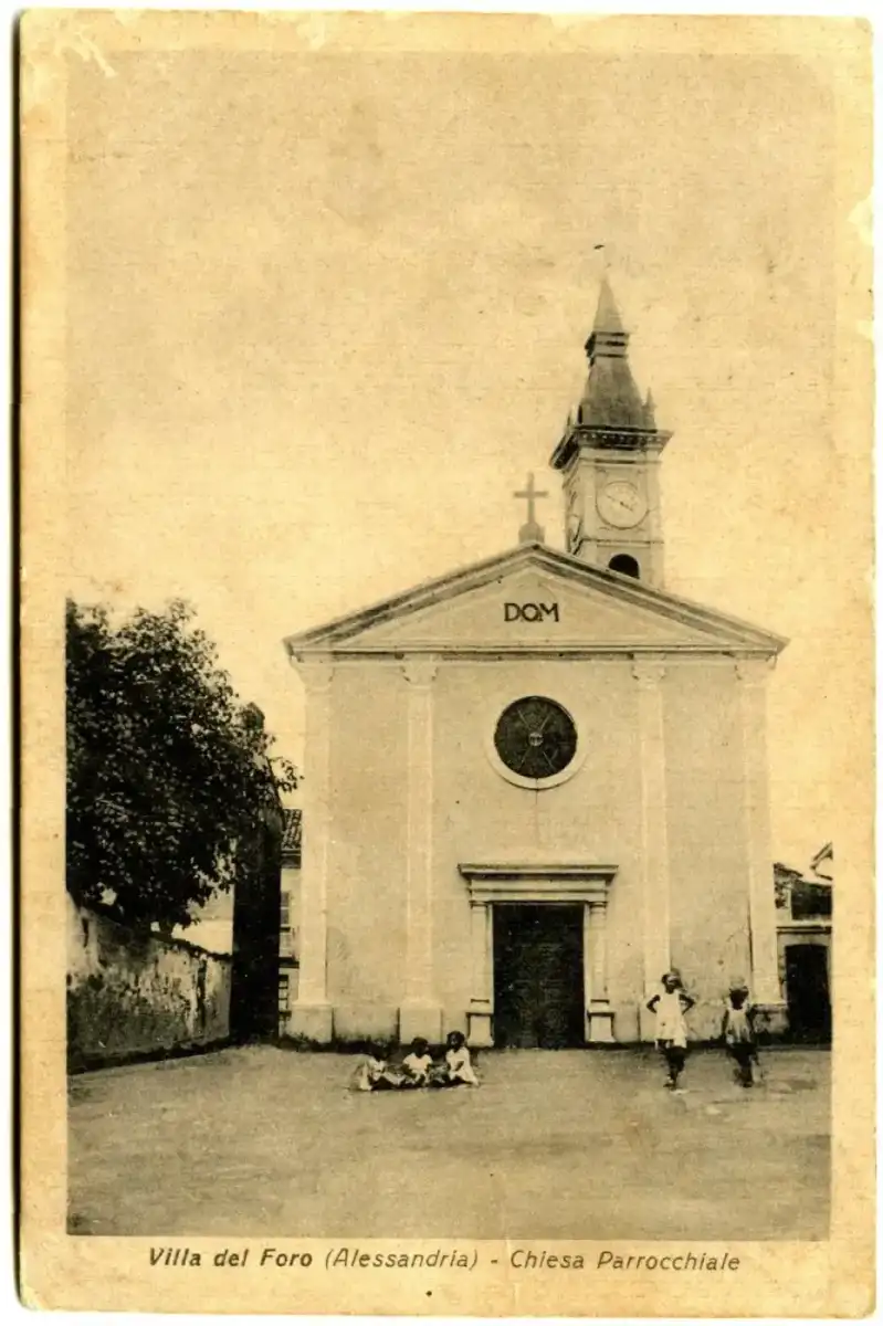
Of the most recent times is the church in the center of the village, in Via Maestra, dedicated to Santa Varena and the elementary school in via Oviglio, now disused but partially restored and used as an archaeological museum. It is also called "a town with two saints": Santa Varena and San Baudolino; there is also the small church of San Rocco in via Oviglio.
Notes
Explanatory statement · BibliographicExplore this chapter
Explanatory statement
- ^ From here the name assigned to the Diocese of Alessandria: "Dioecesis Alexandrina Statiellorum". Annals of Alessandria, p. 2-1168/1
- ^ The Ghilini in his Annals of Alessandria, p. 2-1168/1 erroneously wants that the birth of the city took place on 22 April 1168, that is the same day as the foundation of Rome: "[...] пеl what day Romulus gave rise to the fabrica of the City of Rome [...]". Ghilini makes more than one mistake: the foundation of Rome is officially set on April 21st, and - in reality - the name Caesarea was imposed by the emperor in Reconciliatio Cæsareæ of 1183 (Germaniæ Historica Monument, pp. 181-182), which was soon abandoned by the inhabitants themselves as an element foreign to their collective conscience and individuality. Geo Pistarino, p. 15
- ^ In the first twenty years of its history, the city presents four different names in sources: Alessandria Caesarea[2], Palea, Rovereto, in addition to the quite frequent generic designation of civitas nova or nova civitas, and to the rarer designation of urbs nova. (Geo Pistarino, p. 15).
Bibliographic
- ^ Codex Statuterum, p. 439
- ^ Geo Pistarino, p. 14
Bibliography
Explore this chapter
- Silvana Finocchi, Alessandria, fraz. Villa del Foro. Roman town of Forum Fulvii (PDF), in Quaderni della Soprintendenza Archeologica del Piemonte, vol. 7, Turin, Archaeological Superintendence of Piemonte, 1988, pp. 47-50. Retrieved 20 June 2016.
- Girolamo Ghilini, Annals of Alessandria, Milan, Gioseffo Marelli, 1666.
- Francesco Moscheni & F.lli, Codex Statuterum magnifice communitatis atque diœcæsis Alexandrinæ, Alessandria, 1547. Retrieved 9 June 2016.
- Geo Pistarino, The double foundation of Alessandria (1168, 1183) (PDF), in History magazine Art Archaeology for the provinces of Alessandria and Asti, single volume, Alessandria, Society of History Art Archeology - Accademia degli Immobili, 1997, pp. 5-36. Retrieved 11 June 2016.
- (THE) Georg Heinrich Pertz (ed.), Reconciliatio Cæsareæ, in Germaniæ Historica Monument, II, Hannover, 1837. Retrieved 16 June 2016 (archived fromoriginal url on 12 August 2016).
- Marica Venturino Gambari, Alessandria, fraz. Villa del Foro. Iron Age Necropolis and Abitate (PDF), in Quaderni della Soprintendenza Archeologica del Piemonte, vol. 1, Turin, Archaeological Superintendence of Piemonte, 1982, p. 144. Retrieved 20 June 2016.
- Marica Venturino Gambari, Alessandria, fraz. Villa del Foro. Savi in the town of the first Iron Age (PDF), in Quaderni della Soprintendenza Archeologica del Piemonte, vol. 7, Turin, Archaeological Superintendence of Piemonte, 1988, pp. 45-47. Retrieved 20 June 2016.
- Marica Venturino Gambari, Alessandria, fraz. Villa del Foro. Scavi in the area of pre-protostoric housing (PDF), in Quaderni della Soprintendenza Archeologica del Piemonte, vol. 12, Turin, Archaeological Superintendence of Piemonte, 1994, p. 262. Retrieved 19 June 2016.
- Roman dress in the area of Alexandria - Forum Fulvii (PDF), Alessandria, Fondazione Cassa di Risparmio di Alessandria, 2013, pp. 54-59. Retrieved 19 June 2016 (archived fromoriginal url on August 10, 2016).
- Emanuela Zanda, Maria Cristina Preacco Ancona and Mauro Somà, Forum Fulvii and Hasta necropolis nucleus (PDF), in Quaderni della Soprintendenza Archeologica del Piemonte, vol. 12, Turin, Archaeological Superintendence of Piemonte, 1994, pp. 127-192. Retrieved 19 June 2016.
- Emanuela Zanda, Centuration and city (PDF), in Liliana Mercando (ed.), Archaeology in Piemonte. II. The Roman Age, vol. 2, Turin, 1998, pp. 49-66. Retrieved 1 May 2019.
Continue your journey